
 Itching to shred the gnar and leave first tracks on the fresh pow-pow this winter? Translation: Excited to ski or snowboard on the freshly fallen powder this winter? As we wait for opening day on Vail Mountain with anticipation, let's take a moment to appreciate the forces of nature that have given us slopes to ski on all winter long, like the Minturn Formation, which covers the majority of Vail Mountain.

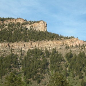
The Minturn Formation is partially responsible for the terrain that allows us to enjoy winter recreation, but it’s better known for its colorful strata that adds to the long list of attributes that make Colorado such a beautiful state. Named after the quaint town of Minturn, a portion of the formation can be spotted on I-70, north of the Eagle River-Gore Creek confluence. Generally, a geologic formation consists of a number of layered rocks (strata) with similar properties. The strata of the Minturn Formation tell the story of Colorado when the landscape was unfamiliar—a time when a giant, shallow sea covered the majority of the state.
Enter the Carboniferous Period, a geologic time that began 358 million years ago. To better understand such an immense timespan, let’s shrink the entire 4.6-billion-year geologic time scale to just one calendar year, where each second represents about 146 years. In this time scale, if the Earth formed at the second the New Year began on January 1st, the Carboniferous Period would span from December 3rd to December 9th (that’s one heck of a gap!), and today would be New Year’s Eve, December 31st. At the start of the Carboniferous Period, Colorado was under a warm shallow sea, teeming with aquatic life.
December 6th, halfway through the Carboniferous Period, marks the beginning of the Pennsylvanian subperiod (320 million years ago)—a time period recognized to have created the first extensive coal deposits derived from compressed vegetation. During that time, Colorado began to rise as a result of tectonic activity, creating the Ancestral Rocky Mountains in the middle of a sea. Similar to the modern day Front Range, the Ancestral Rockies separated the Central Colorado Trough (which roughly begins southwest of the Gore Fault) from the Colorado Eastern Plains (located east of the Rocky Mountains). Today, the Ancestral Rockies no longer exist in their true form, as they eroded over millions of years, however, the sediment eroded was carried through rivers and streams that cyclically fed into the ocean. Occurring on both east and west sides of the Ancestral Rockies, sediment was carried through the mountains and into the ocean where they slowed and settled, creating alluvial fans, fan shaped accumulations of sediment on the sea floor. After millions of years of continual erosion and sea floor sedimentation, the erosion and subsequent deposition of the Ancestral Rockies formed the strata we see today in the Minturn Formation.

At the time of deposition during the Pennsylvanian period, the sedimentary rock was underground and mostly horizontal. Just in time to be a late Christmas gift, on December 26th (about 72 million years ago), the modern Rocky Mountains began to rise due to the collision of the Pacific and North American tectonic plates, resulting in the high mountain ranges and valleys we know today. It was this activity that lifted underground formations like the Fountain Formation seen at the Red Rocks amphitheater near Denver, the Hermosa Formation near Ouray, and of course, the Minturn Formation here in the Central Colorado Trough, all stemming from the same Pennsylvanian-age uplifts and erosion.
So next time you decide to conglomerate with friends at a local Minturn café, rock out at Red Rocks Amphitheater, or traverse Vail Mountain, remember the Minturn Formation and the story it tells of mountains that rose from the sea.
Gerardo Aguilera is a Naturalist and Sustainability Intern at Walking Mountains Science Center in Avon. He likes to ‘dig deep’ and learn about the world around him so that he can better understand his connection to the cosmos.
Footnotes:
The Geologic Time Scale. Digital image. University of Kentucky. Kentucky Geological Survey, Web. <https://www.uky.edu/KGS/education/geologictimescale.pdf>.
De Voto, Richard H. "Pennsylvanian and Permian Stratigraphy and Tectonism in Central Colorado." Quarterly of the Colorado School of Mines: Paleozoic Stratigraphy and Structural Evolution of Colorado. Number ed. Vol. 67. Golden, Colorado: Colorado School of Mines, 1972. 139-85. Print. Number 4.


