We like our powder light and fluffy in Colorado and there are many reasons we’re blessed with “champagne or blower pow.” In order to plan your perfect day of riding, skiing, sledding, or even snow shoveling, it’s helpful to know factors that influence snow quality, such as snow to water ratio, temperature, moisture and finally wind.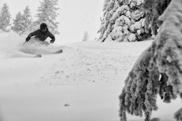 Light snow is defined as snow that has low water content, most easily measured as a ratio. If 15” of snow is melted and yields 1” of water, the snow to water ratio is 15 to 1. The higher the ratio the better chances for blower pow and this 15 to 1 ratio, or higher, is common in Colorado mid-winter. Lower ratios such as 10 to 1, make the snow feel heavier and are more common in springtime or maritime snow climates. The best powder days are a result of a ratio of 20 to 1 and connoisseurs remember these rare days.
Temperature is the first weather factor influencing the formation of perfect pow and something we usually check before going outside anyway. The ideal temperature for the formation of light snow is 0°-10°F, colder temperatures typically produce less snow while higher temperatures produce lower ratio snow. In Eagle County, temperatures are influenced by a number of factors, including season, geography and elevation. At an elevation of 8150’, the average high temperatures for Vail, January through February are 28°-33 F and average low temperatures are 5°-8°F. Typical temperatures at ski area mountain tops are even colder, decreasing 3°-5°F per 1000’ in elevation gain, meaning temperatures are typically perfect for the formation of light snow.
The available moisture contained in passing storms also influences the formation of desirable pow. In our region of Colorado, NW flow weather systems are more favorable for snowfall and our snowpack region is defined as Continental, far from the influence of ocean weather systems. For example a weather front on a NW flow will deposit most of its moisture on the Pacific Northwest, then the mountains in Idaho, Montana and Utah, and finally reach the Colorado Rockies, where snowfall amounts are typically less and storm moisture content is lower. Of course, geographic variations exist such as Wolf Creek Pass, Schofield Pass, and Buffalo Pass, which typically have the highest snowfall amounts in Colorado.
 The current more favorable snowpack depth in Colorado is due to the Atmospheric River that formed over the Pacific Ocean off the coast of California in late December. This storm brought both significant amounts of snow and high moisture content snow. Ski areas such as Crested Butte and Aspen were the most favored by this pattern and received over 90” of snow in this two-week period! Fortunately, Vail and Beaver Creek received respectable snowfall as well, and some of it had a lower snow to water ratio than typical for this time of year.
Finally, wind has a significant effect on snow during and after snowfall, in some cases more so than temperature. Light winds paired with temperatures 0°- 10°F are more conducive to the formation of stellar dendrite crystals, the iconic snowflake shape, that loosely lands on the ground with a good deal of airspace. Winds in excess of 15mph will change the shape of snow crystals, creating rimmed or round crystal shapes that pack more tightly on the ground. Once on the ground, wind can transport snow two to three times faster than the amount falling out of the sky, resulting in further compaction. High winds during and after snowfall contribute to wind affected snow and wind slabs. Wind slabs make for more challenging riding and skiing conditions and elevate avalanche hazard on steeper terrain, including slopes steeper than 30 degrees which is similar to a typical blue/black run at our local ski areas. If you’re familiar with Vail’s back bowls, then you’re already aware of predominant wind directions, scouring Forever and creating large cornices on Apres Vous, Gengis Kahn and Lover’s Leap in Blue Sky Basin. The areas below these cornices often have the deepest snow on a power day, and depending on wind speeds, the quality of snow varies.

Finally, wind has a significant effect on snow during and after snowfall, in some cases more so than temperature. Light winds paired with temperatures 0°- 10°F are more conducive to the formation of stellar dendrite crystals, the iconic snowflake shape, that loosely lands on the ground with a good deal of airspace. Winds in excess of 15mph will change the shape of snow crystals, creating rimmed or round crystal shapes that pack more tightly on the ground. Once on the ground, wind can transport snow two to three times faster than the amount falling out of the sky, resulting in further compaction. High winds during and after snowfall contribute to wind affected snow and wind slabs. Wind slabs make for more challenging riding and skiing conditions and elevate avalanche hazard on steeper terrain, including slopes steeper than 30 degrees which is similar to a typical blue/black run at our local ski areas. If you’re familiar with Vail’s back bowls, then you’re already aware of predominant wind directions, scouring Forever and creating large cornices on Apres Vous, Gengis Kahn and Lover’s Leap in Blue Sky Basin. The areas below these cornices often have the deepest snow on a power day, and depending on wind speeds, the quality of snow varies.
Resources
https://sciencing.com/snow-form-4563981.htmlhttps://en.wikipedia.org/wiki/Orion%27s_Belt
https://snowbrains.com/snowpack-depth-at-north-americas-resorts-9/
https://www.nationalgeographic.org/encyclopedia/snowpack/
https://www.noaa.gov/stories/what-are-atmospheric-rivers
https://www.usgs.gov/news/featured-story/rivers-sky-6-facts-you-should-know-about-atmospheric-rivers
https://snowbrains.com/snowpack-climates-explained/
Markian Feduschak is the President of Walking Mountains Science Center and a self-described snow geek and passionate skier. Markian is also a board member of the Friends of the Colorado Avalanche Information Center, a nonprofit organization that supports the Colorado Avalanche Information Center.


