
Mejores Perros de Colorado / Tops Dogs of Colorado
Mejores Perros de Colorado
 A veces, nuestra naturaleza curiosa no se satisface tan fácilmente.
No hace mucho, me encontré mirando hacia abajo en el lago Pitkin hacia nuestro valle. Disfrutar de la vista fue un buen descanso del estado general de ansiedad que a menudo acompaña a los largos días de trepidación alpina, diversión tipo 2 en su máxima expresión. Antes de confiar en mi siguiente agarre, colocó una mano sobre el pequeño bloque de roca y golpeó su costado.
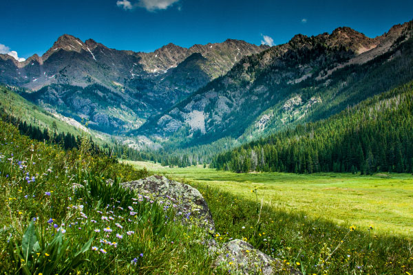
El lago de abajo es un destino popular y un digno desafío aeróbico. Sin embargo, para aquellos de nosotros que vemos los senderos como rutas de acceso en lugar de destinos, las crestas de arriba son irresistibles. La cordillera Gore ofrece una cresta casi continua de * en su mayoría * de alta calidad, desde Eagle Nest Peak en su término noroeste hasta Buffalo Peak, a unas 30 millas al sureste. El granito en su mayoría sólido (para Colorado), como lo demuestra el reconfortante "zumbido" y la falta de vibraciones que sentí al darle un golpe sólido, contribuye en gran medida a hacer que un día de tipo 2 sea un poco, bueno, más divertido. Sin embargo, a solo unas millas de distancia, el primo sur de Gore, el Sawatch Range tiene una sensación notablemente diferente. Después de años de explorar ambos rangos, no puedo evitar preguntarme por qué estos dos son tan cercanos en geografía pero tan diferentes en carácter.
¿Por qué el monte. de las laderas orientales de la Santa Cruz clásicamente glaciares, con cerros empinados y lagos alpinos, mientras que su lado occidental es tan moderado ¿Por qué la mayoría de los Sawatch 14 se parecen más a colinas altas y onduladas (a las que algunos de mis amigos se refieren como "las colinas de los topos") que a los picos escarpados y las agujas de Gore? Y lo más importante, ¿por qué la roca es tan buena en el lado norte de la I-70 y tan mala en el sur?
¡Es hora de convertirse en geólogo!
No importa. Resulta que la geología es difícil.
Me propuse escribir este artículo como motivación para finalmente encontrar algunas respuestas. Sin embargo, como sucede a menudo cuando trato de convertirme en un experto en un campo completo del estudio científico, me he ido con solo algunos datos interesantes y muchas más preguntas. 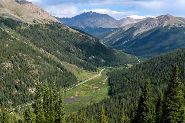
Al igual que con el resto de los picos de Colorado, la Cordillera Gore tiene sus orígenes en el levantamiento de Laramide hace 40-60 millones de años. Se elevó a las alturas actuales, y continúa subiendo, en un levantamiento posterior que elevó la meseta de Colorado adyacente desde el nivel del mar a las alturas actuales.
Gore Range es una cadena montañosa de bloques de fallas, similar a los Tetons. Las montañas de bloques de fallas se crean cuando la corteza en un lado de una falla cae, mientras que el otro se eleva, en lugar de que ambos lados se empujen entre sí. Las crestas de cuchillos y los pintorescos cerros que dan a Gore su estética actual fueron esculpidos durante un período reciente de glaciación alpina que caracterizó la mayor parte de los últimos 3 millones de años, que terminó hace solo 10-15,000 años.
La gama Sawatch, por otro lado, es la mitad de un gran anticlinal, esencialmente una protuberancia gigante en la corteza terrestre. La otra mitad de esta formación es la Cordillera de los Mosquitos, separada de su gemelo por el Valle del Río Arkansas, que fue formado por el Rift del Río Grande hace 20-30 millones de años. Estos picos también estuvieron cubiertos por glaciares expansivos durante gran parte de los últimos 3 millones de años. Sin embargo, por alguna razón, estos glaciares dejaron su huella de una manera menos dramática.
Hace millones de años, estas cumbres pueden haber sido franjas de una mega furia, miles de pies más altas. Sin embargo, el Rift del Río Grande y millones de años de erosión han barrido miles de pies de roca sedimentaria, dejando el granito quebradizo que disfrutamos hoy.
Gracias por eso, erosión.
Entonces, después de horas de navegar por Internet e intentar descifrar la jerga geológica, todavía tengo curiosidad. ¿Algo sobre la naturaleza de la formación del anticlinal explica la estética moderada del Sawatch? ¿O hay algo en el tipo de roca que compone estos dos rangos que explica sus diferencias?
Quizás esta sea mi historia de origen geólogo. Tal vez regrese en 50 años con grandes palabras y algunos doctorados, el equivalente enloquecido y demacrado de la geología del Regreso al futuro Doctor Brown, para escribir la secuela de este artículo. Quizás.
Mientras tanto, sin embargo, puede encontrarse en el lado norte de la I-70, luchando por mis días en Gore, todavía preguntándome.
Mantén la curiosidad, amigos míos.
Recursos:
https://pubs.usgs.gov/bul/1319c/report.pdf
http://igp.colorado.edu/library/video/84255609
http://igp.colorado.edu/library/video/84255609
http://www.cliffshade.com/colorado/gore/
Nathan Boyer-Rechlin es el coordinador de alcance comunitario en Walking Mountains Science Center. Todavía no es geólogo, pero no lo descarte en el futuro.
Sometimes, our curious nature isn’t so easily satisfied.
Not too long ago, I found myself looking down on Pitkin Lake to our valley below. Taking in the view was a nice break from the general state of anxiety that often accompanies long days of alpine scrambling, type-2 fun at its best. Before trusting my next hold, I place a hand on the small block of rock and pound its side.
The lake below is a popular destination, and a worthy aerobic challenge. However, for those of us who see trails as access routes rather than destinations, the ridgelines above are irresistable. The Gore Range offers a nearly continuous ridgeline of *mostly* high quality scrambling from Eagle Nest Peak at its northwestern terminus all the way to Buffalo Peak, some 30 or so miles southeast. The mostly solid (for Colorado) granite, as evidenced by the comforting “whump” and lack of vibrations I felt when giving it a solid pounding, goes a long way to making a day of type-2 fun slightly, well, more fun.
Just a few miles away, however, the Gore’s southerly cousin, the Sawatch Range has a notably different feel. After years of exploring both ranges, I can’t help but wonder why these two are so close in geography but so different in character?
Why are Mt. of the Holy Cross’s eastern slopes classically glaciated, with steep cirques and alpine lakes, while its western side is so moderate? Why do most Sawatch 14ers look more like tall, rolling hills (referred to by some of my friends as ‘the mole-hills’) than the craggy peaks and spires of the Gore? And most importantly, why is the rock so good on the north-side of I-70, and so bad on the south?
Time to become a geologist!
Nevermind. It turns out geology is hard.
I set out to write this article as motivation to finally find some answers. However, as often happens when trying to become an off-the-couch expert in an entire field of scientific study, I’ve walked away with just a few interesting facts and many more questions.
As with the rest of Colorado’s peaks, the Gore Range has its origins in the Laramide uplift 40-60 million years ago. It rose to current heights, and continues to rise, in a subsequent uplift that elevated the adjacent Colorado Plateau from sea level to current heights.
The Gore Range is a fault-block mountain range, similar to the Tetons. Fault-block mountains are created when the crust on one side of a fault drops, while the other uplifts, rather than both sides pushing into each other. The knife ridges and picturesque cirques which give the Gore its current aesthetic were sculpted during a recent period of alpine glaciation that characterized most of the last 3 million years, ending just 10-15,000 years ago.
The Sawatch range, on the other hand, is half of a large anticline, essentially a giant bulge in the earth’s crust. The other half of this formation is the Mosquito Range, separated from its twin by the Arkansas River Valley which was formed by the Rio Grande Rift 20-30 million years ago. These peaks were also covered in expansive glaciers for much of the last 3 million years. However, for some reason, these glaciers left their mark in less dramatic fashion.
Millions of years ago, these summits may have been fringes of one mega rage, thousands of feet taller. However, the Rio Grande Rift and millions of years of erosion have swept away thousands of feet of sedimentary rock, leaving the crumbly granite we enjoy today.
Thanks for that, erosion.
So, after hours of pouring through the internet, and attempting to decipher geological jargon, I’m still curious. Does something about the nature of anticline formation explain the Sawatch’s moderate aesthetic? Or is there something about the type of rock that makes up these two ranges that explains their differences?
Maybe this is my geologist origin story. Maybe I’ll come back in 50 years with big words and a few PhDs, geology’s crazed and haggard equivalent of Back to the Future’s Doctor Brown, to write this article’s sequel. Maybe.
In the meantime, however, you can find me on the north-side of I-70, scrambling my days away in the Gore--still wondering.
Stay curious my friends.
Sources:
https://pubs.usgs.gov/bul/1319c/report.pdf
http://igp.colorado.edu/library/video/84255609
http://igp.colorado.edu/library/video/84255609
http://www.cliffshade.com/colorado/gore/
Nathan Boyer-Rechlin is the Community Outreach Coordinator at Walking Mountains Science Center. He’s not a geologist yet, but don’t rule it out in the future.


Cuando escuchamos las palabras lobezno, glotón, o wolverine (como se conoce en inglés), lo primero...