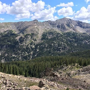
If you had to pick one hike in the Eagle Valley to experience a little of everything our mountains have to offer, the Iron Edge Loop would have to be that hike. Located outside of Eagle, past Yeoman Park, this hike features high alpine ridgelines, mixed forests, lush wetlands, and an iconic subalpine lake. Additionally, in a valley where most of our hikes consist of our and back treks, this loop only repeats about 100 yards of trail!
Getting There:
Follow Brush Creek Road out of Eagle past the Sylvan Lake State Park information center. At the Y in the road just after the center, take the left fork towards Yeoman Park. Continue past Yeoman Park to the Fulford Caves Campground. Park here and hike on the obvious fire road heading up the creek valley. About 100 yards into the hike you will see signs for the Iron Edge & Lake Charles trails, you can hike the loop in either direction!
What to Expect:
The Iron Edge Loop is a challenging hike, and you should be acclimatized to high altitude and in good hiking shape before attempting this route. The full day measures at 11.5 miles & 2,700 ft. of elevation gain. Expect sustained climbs, some loose & rocky sections of trail, and primitive, sometimes hard to follow, sections of trail through sub-alpine wetland.
The recommended approach to this loop is hike it counter clockwise, starting with the ascent to the Peter Estin Hut on the Iron Edge trail and returning down the Lake Charles trail. This front-loads the elevation gain, and will more quickly get you through the high alpine terrain—which is beneficial as we are starting to see regular afternoon thundershowers. 3 miles of steady uphill will bring you to the Peter Estin Hut. From the hut, follow the trail another mile to tree-line. Continue along the ridge for another mile before beginning your descent to Lake Charles. The trail becomes faint in places, but regularly placed cairns guide your way, just make sure you see the next one before continuing on! Once at Lake Charles, enjoy the vistas across the lake before crossing the outflow and merging onto the well traveled Lake Charles Trail. Once you join the Lake Charles trail, you have 4.5 miles of descent to take you back to the trailhead!
Walking Mountains Hiking Programs!
Join the Walking Mountains Hiking Club for a full day hike on Tuesdays or Thursdays ($80 for the day, $500 for the season), or come along for one of our free community hikes! For details on programs, and to register visit walkingmountains.org/hike or email hike@walkingmountains.org
This Week’s Schedule:
Thursday July 23: Craig Peak Full Day Hike, $80 (or $500 for season club membership)
Sunday July 26: Pika Project Community Science Hike to West Lake Creek, free
Monday July 27: Alpine Wildflowers Hike at Shrine Ridge, free
Tuesday July 28: Bald Mountain Full Day Hike, $80 (or $500 for season club membership)