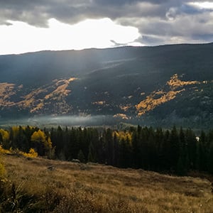
The Eagle River valley is in the hart of peak foliage season—and with the first snow due in just a couple days, its time to squeeze in those last few fall colors hikes of 2019! One of my favorite foliage hikes in the valley is currently boasting spectacular colors—with fiery red & orange aspens evoking images of a New England fall. The Whiskey Creek Loop is a classic moderate to challenging 10 mile loop that is now even better with the recent completion of the Evercrisp Trail!
Getting There:
This hike is centrally located in the Vail area. Exit I-70 at the Minturn Exit, and take highway 24 South. Just after you turn onto highway 24, turn into the U.S. Forest Service Ranger Station parking lot (park across from the ranger station the large parking lot) to access the Meadow Mountain trailhead. This hike can be done combines three trails, Evercrisp, Whiskey Creek, and Meadow Mountain. I recommend hiking this loop counter clockwise. This direction means you will enjoy the steeper climb through gorgeous aspen & fir forest on the ascent, and reap the rewards of a slightly mellower descent through the open Meadow Mountain—with sweeping views of the Gore Range in front of you the entire way down.
To hike the loop in this direction, follow the Meadow Mountain trail, switch-backing up an old road, 0.7 miles to the junction of the Evercrisp Trail. Then contour northwest on the Evercrisp trail about 1.5 miles to the signed junction with Whiskey Creek. The Whiskey Creek trail will take you to the Line Shack, an old hut at the top of Meadow Mountain, from which you will follow the old service road down Meadow Mountain back to your car.
What to Expect:
This is a moderately challenging loop, featuring 2,100 ft. of elevation gain in 10 miles. The first two miles along the Evercrisp trail are along rolling terrain. When you turn left on Whiskey Creek, get ready for the grade to steadily increase, with the steepest mile gaining over 600 ft. This portion of the trail leaves behind the noise of I-70 and takes you through some of the most beautiful aspen forests in Eagle County. Moose have recently been seen in this area—so keep an eye out! Once you start to break into open meadow & aspen forest, the trail mellows and starts to contour towards the Line Shack. From the top of the loop, descend the old road 4.5 miles back to the parking lot. The aspen groves at the top of Meadow Mountain are currently featuring some of the most vibrant foliage in the county!
Nathan Boyer-Rechlin is the Community Outreach Coordinator, and manages all things hiking, for Walking Mountains. For questions about fall hiking with Walking Mountains, or current trail conditions, you can reach him at (970) 817-9725 x144, or email hike@walkingmountains.org


