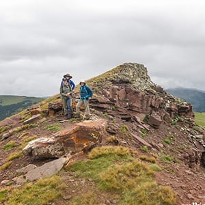
Trail Name: Machinegun Ridge
Alpine flowers are finally coming into their peak in the Eagle River Valley, and there is no better place to find them than Machine Gun Ridge. This moderate hike combines sweeping vistas and beautiful alpine flora with history; the trail retraces the footsteps of the 10th Mountain Division. Named for its history as a training ground, and its place overlooking Camp Hale, it is not uncommon to find shells and remnants of the 10th Mountain Division presence while hiking along Machine Gun Ridge.

Getting There:
There are two ways to access Machine Gun Ridge. For those with high clearance and 4×4 vehicles, a rough but doable road provides the best access for this hike. Take U.S. Highway 24 towards Leadville, and turn into Camp Hale and onto Resolution Mountain Road. Follow this road all they way to the top of the pass.
If your vehicle is not up to the rough mountain roads, you can also access the ridge by hiking up the Wilder Gulch trail from Vail Pass. After the Wilder Gulch trail joins the jeep road, continue up to the top of the pass. This approach does make this hike a longer day and a more challenging endeavor.
What to Expect:
From the top of Ptarmigan Pass, follow a faint trail up to the high point on the ridge. From here, the hike along the ridge can be as long or short as you would like. Our suggestion is a 5.5-mile round trip hike to Sugarloaf Peak. This route hikes along rolling and easy terrain, with a short more difficult scramble to reach the summit of Sugarloaf Peak. Once atop the peak, you will find remnants of old bunkers built into the talus stone.
No matter how far you hike along the ridge, this route features stunning alpine wildflowers, wildlife including marmots and pikas, and excellent views of Mount of the Holy Cross and the Gore Range.
Note on Conditions:
While a faint trail leads you along most of the ridge, it is likely that you will find yourself hiking off-trail through some alpine terrain on this hike. When no trail is present, the best leave-no-trace practice is to spread out so your party does not create a new trail. Alpine vegetation is fragile, and following in your friends’ footprints can cause irreversible harm. As best as possible, follow existing trails and stick to rocky and durable surfaces.


